The government have published their response to the Ordnance Survey Data consultation, for which we made a respond online tool. It looks good. It’s 60 pages long, and I haven’t read it properly, but the broad strokes are right.
There were 441 responses overall, and our tool was used to send 128 — which means nearly a third of the responses came from ernestmarples.com supporters and their friends. I’ve been told by a friendly civil servant that this was a significant influence on the outcome of the consultation, so — seriously — you guys rock. This is overwhelmingly awesome.
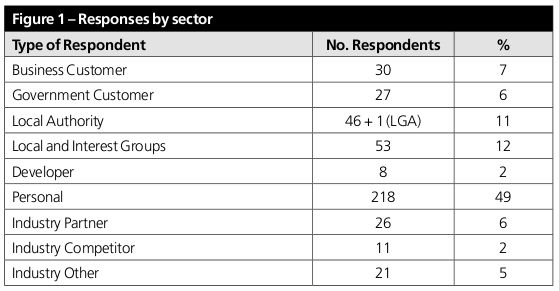
On top of that, some more responses will have come via PlanningAlerts users, as used his lists there to ask people to reply directly. In the final calculation, 51% of the responses came from individuals and developers, and only 7% from OS’s business customers. An exceptional result.
The full breakdown:

The products that will be released are:
- OS Street View
- 1:50 000 Gazetteer
- 1:250 000 Scale Colour Raster
- OS LocatorTM
- Boundary-LineTM
- Code-Point® Open
- MeridianTM 2
- Strategi®
- MiniScale®
- OS VectorMapTM District (available 1 May 2010)
- Land-Form PANORAMA®
A pretty substantive collection, all in all. Excitingly, the presence of Code-Point means that ErnestMarples.com is now officially redundant. Yay!
On the vital issue of derived data — the current licence terms that mean that Ordnance Survey has IP rights in any data anyone makes using its data — the response says:
Ordnance Survey will also be proposing changes to the derived data policy for the commercial sector, including ‘Free To Use’ data, as part of its work on revised pricing and licensing.
Ordnance Survey, The National Archives and the Cabinet Office will also work together to ensure that derived data issues do not unnecessarily impede the release of public datasets by other public bodies, balancing the significance of the data taken, the impact of release of any dataset on Ordnance Survey’s commercial business and that of its partners, and any legal or regulatory consequences for Ordnance Survey.
This reflects concerns expressed in the consultation responses about licensing of Ordnance Survey products, and in particular derived data.
To me, this feels a bit unclear on the issue of whether or not derived data rights will affect users of the products OS is releasing for free — but another friendly insider says that I needn’t worry. Whatever form the derived data licence terms end up taking, they won’t affect users of the free datasets. Only the commercial ones. The free datasets will genuinely be free.
More details are set to be released tomorrow.
Other Highlights
The message has clearly sunk in (p23):
Most respondents were, either explicitly or implicitly, supportive of the Making Public Data Public initiative and its rationale. Many noted that there would be significant economic and social benefits from releasing Ordnance Survey data more widely and for free. These included the development of innovative services and products by the private sector, and the delivery of more efficient and effective public services.
People without a vested interest clearly support #opendata (p27):
A number of respondents provided comments in this section [pricing] in support of ‘free data’. A clear majority, 300 responses (68%), felt that either some or all of Ordnance Survey data should be released for free. [...] Some, mainly competitors, thought no data should be made available for free.
Businesses can, and will, change:
A wide range of respondents thought that the overall impact of Ordnance Survey Free on the market would be positive. [...] in the short term there were likely to be adverse impacts on the market, as existing users of the data begin to receive the same products for free, while others migrated from their current paid-for products to the free product set. [...] the market would suffer a short term drop in revenue, but wider access to data would drive long-term growth in the sector as a whole allowing those detrimentally affected to re-evaluate and modify their business models to take advantage of new opportunities [...].
If you find any more — post them in comments!
One Comment
Another highlight for me is the strong wording about Open Source in para 3.28 – OS will build INSPIRE data services using free software, and its work will be “offered back to the community”.
Another (para 3.15) is that OS plans to release the TOID object identifier scheme free to reuse, with Linked Data applications in mind. So sites which do have access to MasterMap will be able to share links to geometries.
Thanks for your now wonderfully redundant work
3 Trackbacks/Pingbacks
[...] This post was mentioned on Twitter by Harry Metcalfe, jamescrabtree. jamescrabtree said: RT @harrym: Our response to Gov's response on Ordnance Survey data consultation: http://bit.ly/auaKwq #opendata #ernestmarples (pithy summary: AWESOME) [...]
Social comments and analytics for this post…
This post was mentioned on Twitter by harrym: Our response to Gov’s response on Ordnance Survey data consultation: http://bit.ly/auaKwq #opendata #ernestmarples (pithy summary: AWESOME)…
[...] was a bit concerned yesterday that the licencing terms for OS OpenData weren’t made clear in the consultation. [...]